
Nee Soon Freshwater Swamp Project
Overview: One of the most important conservation sites in Singapore, the Nee Soon project is working towards establishing an eco-hydrological baseline to conserve this catchment. This project by NParks in collaboration with the Tropical Marine Science Institute (TMSI) aims to integrate various geography, vegetation, faunal and modelling teams to research the status of this 750ha wetland area for stream management and conservation. The Field Hydrology and Geomorphology team under Dr. Z and Bob Wasson attempts to find impacts of land-use and natural changes through sediment cores, metal analysis, GIS mapping and stream monitoring. Below is a sample of what we are doing.
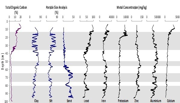
Sediment coring
We have extracted nearly 20 x 1-1.5m cores from the swamp for metal, carbon and stratigraphic analyses to examine the effects of stream flow, erosion and human impacts such as pipeline construction and plantations. Dating results using C-14, Pb-210 and Cs-137 indicate that the cores have a very young sediment profile dating to the 1950s at 30cm. The cores show very few stratigraphic layers yet are highly heterogeneous even with a distance of a few cm! These clay rich cores have been a topic of much discussion for soil texture with our particle size analyser showing silt-dominated sediments instead. This lead to a short study of diatoms which can be silt-sized and was thought to be a contributing factor for the particle size results, however diatom presence was lacking and only a few phytoliths were observed. Also, interesting evidence such as orange material and a much darker, black material at the 1m mark indicate the high level of disturbance in the catchment.


Hydrology
Stream water samples collected from the main streams, as well as storm samples, are analysed for spatial and temporal variations through Total Organic Carbon, cation and anion measurements. The project maintains various field instruments such as the sondes, piezometers, water samplers and velocity profilers. The stream and soil pH is a consistent 4-6pH and the ions tend to increase further downstream. The aim here is to find out why it is increasing in such a way – due to the binding properties of clay? Or are other elements such as Mn controlling these as seen with the surface soil? We are also researching the different correlations between elements such as Fluoride, Nitrates and Potassium which have range of 0.003-17.285 ppm, 0.017-85.935 ppm and 0.04-58.83 ppm respectively.


GIS
Digitising archival maps to see the transformation of the Nee Soon through land-use changes from tapioca and other plantations that were cultivated by Chinese immigrants and French estates in the early 1900s, to reservoirs and urban boundaries of the 1980s onwards.
Trace metal analysis
See Trinh’s page (insert link?)
Cool sightings
The Asian brown tortoise (Manouria emyson) on the Granite Hill at nearly 70m. The rare sambar deer footprints near the lower catchment in Mandai, right under the Expressway! Though there are many spotted in Johor, fewer than 20 remain in Singapore. (Credit: Dr.Z, Photo: Valerie Phang)


